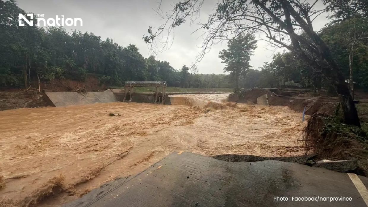
Catastrophic flooding has swept through the forested northern region of Thailand after intense overnight precipitation, with Pua district in Nan province bearing the brunt of the deluge. The National Park office at Doi Phu Kha recorded more than 110mm of rainfall, an extraordinary volume that transformed normally manageable waterways into raging torrents within hours. The crisis emerged early Wednesday morning when residents awoke to find floodwaters already surging through residential neighbourhoods and agricultural lands across multiple subdistricts, giving many families mere minutes to respond before water invaded their homes.
The headwater terrain of Phu Kha subdistrict, characterised by dense forest and steep slopes that naturally channel water rapidly downhill, proved particularly vulnerable. The combination of topography and the sheer intensity of rainfall created a perfect storm for flash flooding—a phenomenon that catches residents off guard because the water arrives with little warning and overwhelming force. Communities in Ban Rong and the villages along the route towards Doi Phu Kha National Park experienced the most severe inundation, with residents scrambling to move family members, pets and essential possessions to higher ground before floodwater breached their doorways.
The physical infrastructure connecting these isolated mountain communities to the broader region has sustained catastrophic damage. A bridge in Ban Na Lae, a critical link on the main route accessing both Doi Phu Kha National Park and Bo Kluea district, was completely washed away by the force of the floodwaters. Similarly, another bridge in the Fai Chao weir area collapsed, further isolating affected populations. The Department of Highways conducted emergency surveys that identified three major sections of Nan Highway District 2 where vehicles cannot pass, effectively cutting off access to Pua from surrounding areas and hampering rescue and relief operations.
Beyond the roads themselves, the wider landscape has become treacherous. The Ouan subdistrict reported multiple landslides as the waterlogged hillsides lost their grip on loose soil and rock. These landslips not only block additional roads but pose ongoing danger to residents, as further collapses remain likely given the saturated ground conditions. The combination of washouts, collapsed bridges and landslides has created a near-total isolation scenario for some communities, leaving officials uncertain how quickly they can reach all affected areas.
For residents, the immediate experience has been chaotic and frightening. Families had virtually no time to salvage valuable belongings or protect livestock before floodwater rushed into their homes. The damage extends beyond individual residences—extensive farmland has been damaged or destroyed, threatening the agricultural livelihoods that sustain these rural communities through the coming months. The loss of crops, irrigation infrastructure and livestock represents not merely inconvenience but potential economic hardship for subsistence farming families.
Recognising the severity of the situation and the need for coordinated response, the Nan Provincial Disaster Prevention and Mitigation Office mobilised multiple agencies to manage the crisis. The Department of Disaster Prevention and Mitigation partnered with mobile network operators AIS, True and NT to issue emergency alerts via the Cell Broadcast system, bypassing normal communication channels to ensure all residents in Pua district received warnings. The message urged immediate evacuation, particularly of vulnerable populations including elderly residents and bedridden patients, while advising people to contact their local administrative leadership for assistance.
The scale of the meteorological event underscores the intensity of the weather system affecting northern Thailand's highlands. The Thai Meteorological Department's Northern Centre reported that Lamphun weather radar detected bands of light to moderate rain spreading across nine provinces in the upper North, with weather systems continuing to move south-westward. This suggests the potential for additional flooding in downstream districts as water runoff from the highlands flows towards lower elevations, a cascading hazard that could affect neighbouring provinces including Phrae and Sukhothai.
For Thailand and the broader Southeast Asian region, these incidents highlight the vulnerability of mountain communities and the infrastructure serving them during extreme weather events. The reliance on single-route road access in forested highlands means that when those routes are damaged, isolation becomes complete and relief becomes difficult. Rural populations dependent on agriculture face particular hardship from simultaneous road damage and crop destruction, creating compounded economic disruption.
The response mechanisms activated—emergency alerts, local authority coordination and survey teams—represent standard Thai disaster protocols, yet their effectiveness depends heavily on pre-positioned resources and accessibility. The current situation, with multiple road failures and landslides, tests the limits of how quickly assistance can reach isolated communities. These events also illustrate why infrastructure resilience and redundant access routes remain critical investments for regions prone to such natural disasters.
As meteorological conditions continue to evolve across northern Thailand, authorities remain on alert for secondary flooding effects as water from the upper reaches flows downstream. The full extent of damage and displacement will become clearer once access to all affected communities is restored, but preliminary reports suggest hundreds of families have been directly impacted and the recovery process will likely extend weeks or months depending on damage assessment findings.

