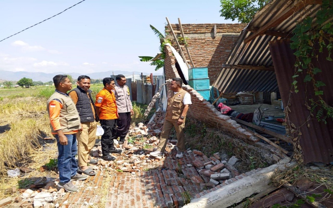
A devastating magnitude 7.7 earthquake struck Indonesia's Flores Island in East Nusa Tenggara early Saturday morning, prompting the evacuation of around 2,000 residents to safer locations. The natural disaster, which hit at 4.58 am local time with its epicentre approximately 30 kilometres from Mbay at a depth of 15 kilometres, triggered swift emergency responses from Indonesian authorities and unleashed a cascade of powerful aftershocks that would continue to unsettle the affected region throughout the day.
According to the National Disaster Management Agency (BNPB), authorities mobilised evacuation efforts immediately after the main tremor, with the majority of residents either being moved to designated safety zones or independently seeking refuge from the destructive force. The initial response reflected the speed and coordination required when dealing with seismic events of this magnitude, as officials worked to prevent further casualties and establish secure perimeters in vulnerable areas.
The tsunami alert issued by the Meteorology, Climatology and Geophysics Agency (BMKG) following the main quake heightened tensions among residents and contributed to the urgency of evacuation operations. However, sea-level observations conducted in the hours following the earthquake indicated that no significant rise in water levels occurred, allowing the agency to lift the warning by 7.31 am. This development, whilst reassuring, meant that focus could shift entirely to terrestrial damage assessment and the management of ongoing seismic activity.
According to preliminary assessments conducted across affected zones, the earthquake's destructive reach was substantial. Fifty-four houses sustained severe damage, nine experienced moderate harm, and eleven suffered minor structural damage. Beyond residential impacts, the disaster affected critical infrastructure including five health facilities, one educational institution, three places of worship, one warehouse operated by state food logistics agency Bulog, and six government offices. Such widespread damage to institutional infrastructure poses significant challenges for post-disaster recovery and community support services.
Manggarai district emerged as one of the hardest-hit areas, recording 29 severely damaged houses alongside nine moderately and nine slightly damaged structures. East Manggarai similarly experienced substantial destruction, with 23 houses severely damaged. These concentrated impact zones suggest that certain geological and infrastructural vulnerabilities in these districts made them particularly susceptible to earthquake damage, a pattern that will likely inform future disaster-resilience planning in the region.
The death toll from the earthquake and its powerful aftershocks had reached 20 by the time initial reports were compiled, whilst six individuals sustained injuries and two others remained trapped in collapsed or damaged structures. These figures underscored the immediate human cost of the disaster and the critical need for rapid rescue and medical response operations. The Maumere Search and Rescue Office coordinated intensive efforts to locate and extract trapped individuals whilst managing the broader humanitarian crisis.
The earthquake triggered 111 recorded aftershocks, a considerable seismic sequence that kept residents on edge and complicated rescue and assessment operations. The frequency and magnitude of these secondary tremors posed ongoing risks to already-damaged structures and hindered the safe deployment of rescue teams in unstable areas. Aftershock sequences of this intensity often extend rescue operations and complicate damage assessment efforts as structural integrity cannot be reliably evaluated until seismic activity subsides.
Communications infrastructure sustained significant disruption, with 200 base transceiver station (BTS) sites across 10 districts and cities in Nusa Tenggara Timur experiencing service interruptions as of 7 am local time. The Digital Infrastructure director-general Wayan Toni Supriyanto indicated that these affected sites represented 16.35 per cent of all BTS infrastructure in the impacted areas. The Communications and Digital Affairs Ministry coordinated with mobile operators to restore telecommunications services, a critical task given that communications networks are essential for coordinating rescue efforts and enabling affected residents to contact relatives and access emergency information.
Disaster assessment efforts remained fluid and incomplete in the immediate aftermath, with the BNPB emphasising that impact data was still being collected, verified, and validated across affected zones. Regional disaster management agencies collaborated with military and police forces, local government officials, and other relevant organisations to conduct comprehensive damage surveys and confirm casualty figures. This multi-layered assessment approach reflects the complexity of evaluating disaster impacts across diverse geographic and administrative zones, particularly in regions where terrain and infrastructure density vary considerably.
For Malaysian readers and the broader Southeast Asian context, this earthquake serves as a sobering reminder of the region's ongoing seismic vulnerability. Indonesia's position along the Pacific Ring of Fire exposes its population to frequent earthquake hazards, and this event demonstrates both the destructive capacity of major seismic events and the institutional capabilities Indonesia has developed for disaster response. Regional cooperation frameworks, including ASEAN disaster management protocols, have evolved substantially to facilitate cross-border assistance when major disasters strike, reflecting the shared vulnerability and interdependence of Southeast Asian nations.
The incident also highlights critical infrastructure resilience challenges that extend beyond Indonesia. Communications disruptions affecting 16 per cent of telecommunications infrastructure in a region underscore how natural disasters can rapidly degrade essential services. For Malaysia and other regional economies, the Flores earthquake illustrates the cascading effects that major natural disasters in neighbouring countries can produce, affecting supply chains, telecommunications networks, and broader regional stability.
Longer-term implications of this disaster will likely shape Indonesian policy discussions regarding building codes, early warning systems, and disaster preparedness investments. The concentration of damage in certain districts suggests that localised vulnerability factors—possibly including construction standards, population density, or geological conditions—created disproportionate impacts. Understanding these patterns proves essential for developing targeted resilience-building strategies that can reduce future casualties and economic losses when inevitable seismic events occur.

