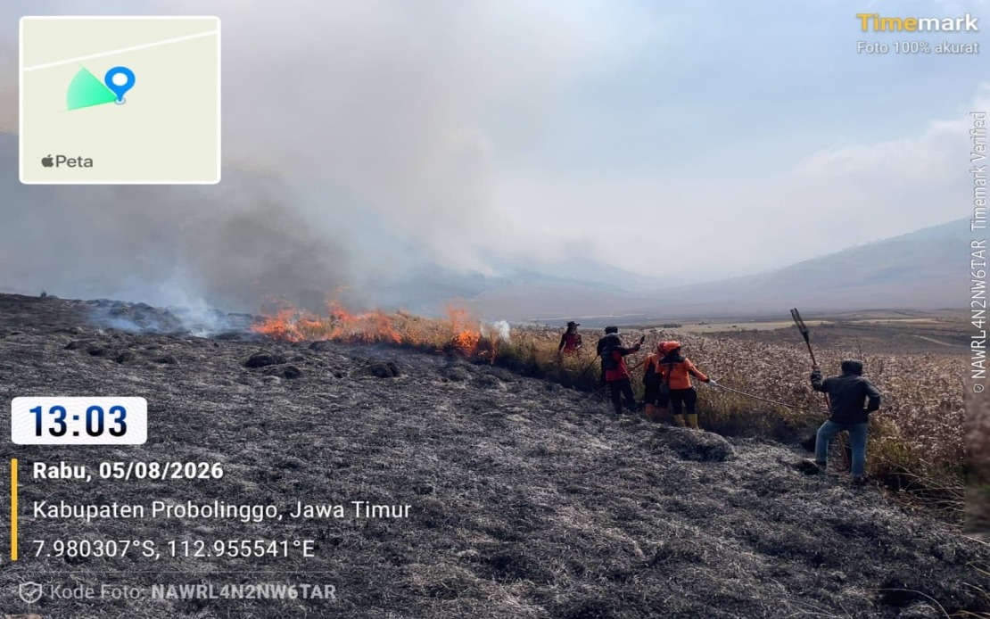
Indonesia's National Disaster Management Agency has committed significant aerial resources to combat a rapidly expanding wildfire at Mount Bromo, deploying two water-bombing helicopters to assist ground teams in suppressing flames that have swept across roughly 60 hectares of terrain in East Java's Probolinggo and Malang regencies. The escalating emergency represents a test of Indonesia's disaster response capacity during the dry season, when vegetation-fuelled fires pose sustained threats to populated regions and ecologically sensitive areas throughout the archipelago.
According to Abdul Muhari, head of the National Disaster Management Agency's Disaster Data, Information and Communication Centre, the blaze ignited on Monday and has proven particularly challenging to contain, with approximately 10 hectares scorched in Probolinggo Regency and a substantially larger 50-hectare burn zone affecting the Bromo Tengger Semeru National Park situated in adjoining Malang Regency. The split geographical distribution of damage underscores the fire's unpredictable spread patterns, as topography and wind conditions interact across protected natural areas that rank among Indonesia's most visited tourist destinations.
The decision to employ aerial firefighting reflects the fundamental limitations confronting ground-based suppression crews navigating the volcanic terrain. Muhari explained that the helicopter squadrons target hotspots positioned on severely sloped mountainsides where human firefighters face prohibitive access challenges and elevated injury risks. This aerial-ground coordination strategy has become routine across Southeast Asia's fire seasons, particularly in Indonesia where helicopter deployment can dramatically accelerate containment timelines for fires in rugged or densely vegetated regions.
By Wednesday afternoon, emergency personnel had achieved substantial progress, bringing most of the active flames under control through intensive ground operations. However, several dangerous hotspots persisted in steep and inaccessible zones, demanding sustained monitoring and suppression efforts by joint emergency response teams comprising personnel from multiple government agencies. The ongoing presence of uncontrolled fire clusters illustrated the distinction between tactical victories—containing the bulk of flames—and complete strategic success, which requires elimination of every remaining ember in an area spanning multiple administrative boundaries.
Beyond immediate firefighting tactics, the National Disaster Management Agency has undertaken preparations for a Weather Modification Operation, contingent upon atmospheric conditions permitting cloud-seeding activities. This supplementary approach attempts to induce rainfall over affected areas, theoretically accelerating fire suppression when atmospheric moisture and temperature conditions align favorably. Such operations remain controversial scientifically and have inconsistent track records, yet during emergencies, Indonesian authorities frequently mobilize this additional tool when conventional suppression methods alone appear insufficient.
The Bromo Tengger Semeru National Park Authority implemented a precautionary temporary closure affecting portions of the Mount Bromo tourist zone, prioritizing both the operational space required for firefighting teams and visitor safety during the active emergency. This decision carries substantial economic implications for regional tourism operators, guides, and hospitality businesses dependent upon steady visitor flows to the iconic volcanic landscape, one of Indonesia's premier trekking and photographic destinations attracting hundreds of thousands of international and domestic tourists annually.
Investigations into the fire's origin have tentatively identified an unattended campfire abandoned by hikers as the probable trigger, a pattern consistent with previous Mount Bromo incidents and reflecting persistent challenges in managing recreation-related fire risks within protected natural areas. The preliminary assessment awaits full confirmation through ongoing investigation, though careless camping practices have repeatedly emerged as significant ignition sources across Indonesian national parks where visitor education and enforcement of safety regulations remain resource-constrained.
The Mount Bromo incident arrives amid broader seasonal fire challenges affecting Indonesia and the wider Southeast Asian region. The dry season amplifies fire risk across forests, agricultural lands, and grasslands throughout the island nations and mainland territories, with particular intensity in Sumatra and Kalimantan. Regional governments coordinate through ASEAN frameworks to address transboundary smoke pollution and coordinate resource sharing, as fires in one nation frequently generate atmospheric haze affecting neighboring countries and their populations.
For Malaysian observers, the Mount Bromo emergency underscores both the technical capacities and the persistent vulnerabilities inherent in managing large-scale wildfires within mountainous and biodiverse landscapes shared across the region. The deployment of helicopter assets, coordination across provincial authorities, and preparation of weather modification systems reflect institutional maturation in Indonesian disaster response since major fire crises of previous decades. Simultaneously, the continued vulnerability to campfire-ignited blazes that spread across tens of hectares indicates that prevention through visitor behavior management and park management remains an ongoing struggle requiring sustained political and budgetary commitment.

