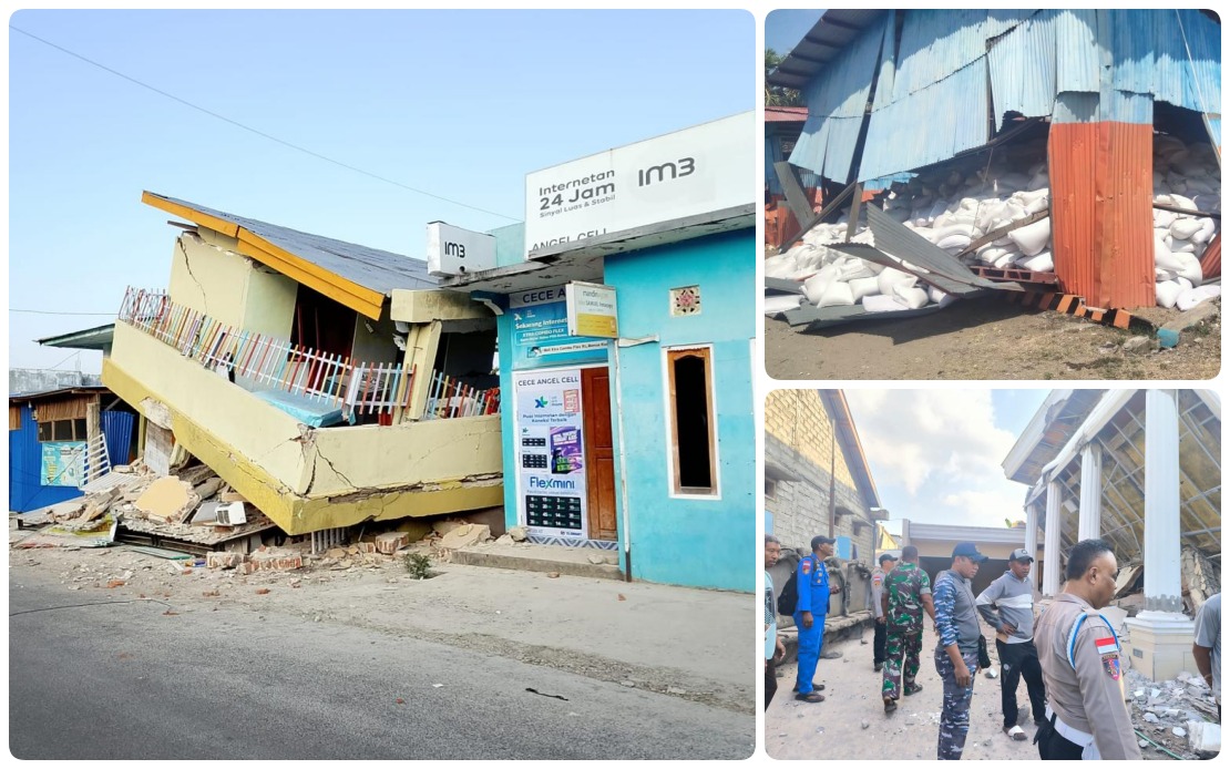
Indonesia's Flores Island continues to reel from the impact of a powerful magnitude 7.7 earthquake that struck in the early morning hours, with authorities reporting at least 53 deaths and thousands of residents still sheltering in evacuation sites as of Sunday. The disaster has unleashed an unprecedented barrage of seismic activity, with the Meteorology, Climatology and Geophysics Agency (BMKG) recording nearly 1,000 aftershocks in the immediate aftermath, intensifying public anxiety even as relief operations gather pace across the stricken island.
According to Abdul Muhari, Deputy of Prevention at the National Disaster Management Agency (BNPB), the BMKG had documented 995 aftershocks by mid-afternoon on Sunday, though only a fraction of these tremors were perceptible to residents. The sheer volume of seismic events underscores the geological instability affecting the region and the heightened alert level maintained by scientists monitoring the situation. While most aftershocks remain below the threshold of human perception, their continued occurrence serves as a constant reminder of the region's vulnerability and the potential for further damage as weakened structures face ongoing seismic stress.
The initial quake struck at 4:58 am local time with its epicentre located approximately 30 kilometres from Mbay in Nagekelo district, positioned in the sea at a depth of 15 kilometres. The tremor triggered an immediate tsunami warning from BMKG, raising fears of a secondary disaster reminiscent of historical calamities. However, authorities lifted the warning at 7:31 am after monitoring coastal sea-level activity and determining that no dangerous waves would materialize. This measured response prevented panic-driven secondary evacuations, allowing response teams to focus resources on immediate relief efforts.
Beyond the current casualties, officials have confirmed 135 people sustaining injuries from the initial quake, with no missing persons officially reported across the seven affected regencies and cities. Abdul Muhari emphasized during a Sunday press conference that authorities have completed preliminary casualty verification across all impacted administrative regions, indicating that initial search and rescue sweeps have concluded without identifying additional persons unaccounted for. However, he cautioned that casualty data would continue to be updated as emergency operations progressed, suggesting that final figures might shift as damage assessment teams expanded their reach into more remote communities.
The persistent presence of evacuees at emergency shelter sites reflects multiple compounding factors beyond immediate structural damage. Psychological trauma stemming from the catastrophic 1992 Flores earthquake and subsequent tsunami remains embedded in community memory, making residents reluctant to return to homes despite engineering assessments declaring them safe. According to data recorded through midnight Saturday, approximately 9,290 individuals remained at designated evacuation points, representing a substantial portion of the affected population. This extended displacement creates secondary challenges for authorities managing food supplies, sanitation, medical services, and psychological support across numerous temporary shelters.
Response operations have now entered their second phase, with BNPB shifting emphasis toward sustained victim support and comprehensive damage evaluation. Emergency teams are prioritizing the distribution of basic supplies including water, food, and hygiene materials to both evacuees and affected households attempting to remain in their homes. Simultaneously, assessment teams are conducting systematic surveys of damaged structures to determine which buildings can be safely occupied after essential repairs and which require reconstruction or reinforcement. This dual-track approach attempts to balance immediate humanitarian needs with long-term recovery planning.
Infrastructure restoration has progressed faster than initially anticipated in certain areas, offering a modest positive indicator amid the broader devastation. A critical section of road in Reok, Manggarai, that had been rendered impassable by landslides triggered during the quake, has been cleared sufficiently to permit fuel tanker trucks to pass through, restoring the supply chain for diesel and petrol essential for powering generators and vehicles. Electricity has been restored to several communities that experienced total blackout conditions immediately following the tremor. These incremental improvements in connectivity and utility services represent crucial steps toward normalizing daily functions and supporting medical facilities dependent on reliable power.
The coordination architecture established by BNPB demonstrates institutional preparedness developed through previous disaster experiences. Response posts have been strategically positioned in Labuan Bajo and Maumere, the two largest urban centres in the affected zone, enabling rapid coordination between field teams, provincial authorities, and national command structures. Complementary logistics hubs activated in Jakarta, Labuan Bajo, and Maumere facilitate the continuous flow of relief materials, specialized equipment, and additional personnel to the disaster zone. This tri-nodal logistics system ensures that supplies accumulating in the capital can be efficiently redistributed to forward positions without creating bottlenecks.
Aircraft and helicopter assets have been placed on operational standby to provide rapid response capability should situation deteriorate or rescue teams require aerial support. The availability of aviation assets carries particular significance for an island geography where certain communities remain accessible primarily by air during periods of severe weather or infrastructure disruption. The pre-positioning of these resources demonstrates recognition that continued aftershocks could trigger additional landslides or structural collapses necessitating emergency evacuation of isolated populations or rapid delivery of critical supplies to communities cut off by road damage.
For Southeast Asian observers and policymakers, the Flores earthquake underscores the region's persistent seismic vulnerability and the ongoing demands that tectonic activity imposes on disaster preparedness and response systems. The Ring of Fire geography that defines much of Southeast Asia means that large-magnitude earthquakes represent recurring rather than exceptional phenomena, making sustained investment in early warning systems, shelter infrastructure, and trained response personnel essential public goods. The Indonesian experience with multiple major earthquakes has generated valuable operational knowledge, yet challenges remain in fully protecting vast populations distributed across archipelago territories.

