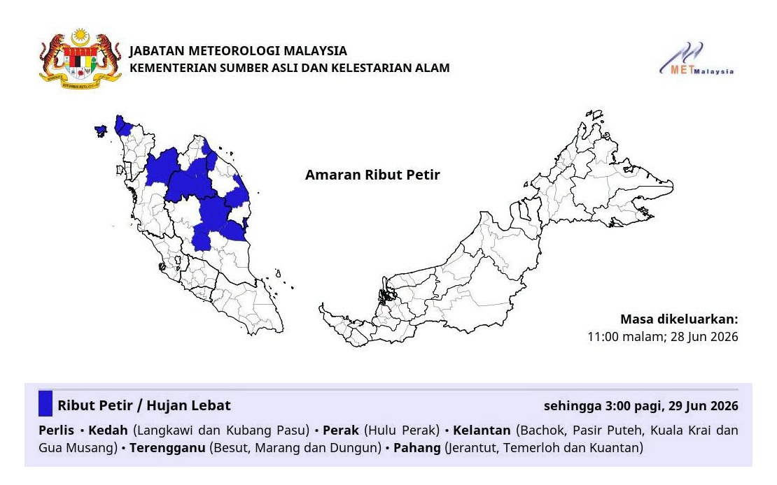
The Malaysian Meteorological Department has issued a weather alert spanning six states across the nation's northern and east coast regions, warning residents and authorities to prepare for significant atmospheric disturbances expected to persist until 3 am. The alert encompasses a broad geographical area stretching from the northwestern peninsula through to the central-eastern coastline, reflecting a widespread weather system affecting multiple regions simultaneously.
Perlis and Kedah face the most extensive warning coverage, with the alert affecting Langkawi and Kubang Pasu specifically. These areas, particularly Langkawi, frequently experience intense convective activity during the monsoon transition periods, and the department's warning reflects the vulnerability of these districts to rapid weather deterioration. Kubang Pasu, located in the mainland section of Kedah, represents another critical area where disruptions to daily activities and transportation networks could materialise quickly.
The threat extends southward into Perak, where the highland region of Hulu Perak requires particular attention. This mountainous district experiences amplified rainfall intensity due to orographic effects, whereby moisture-laden winds encountering elevated terrain generate enhanced precipitation. Residents in this area should remain vigilant regarding potential flash flooding in low-lying valleys and watercourse overflow.
Along the east coast, Kelantan faces the most widespread impact, with the warning covering four distinct localities: Bachok, Pasir Puteh, Kuala Krai and Gua Musang. This multi-district coverage indicates a substantial system rather than isolated thunderstorm cells. Gua Musang, situated in the interior, alongside coastal municipalities like Bachok and Pasir Puteh, suggests the weather system extends across the state's entire topography, from littoral zones to inland highlands.
Terengganu's alert encompasses the eastern coastal municipalities of Besut, Marang and Dungun, all strategically positioned along the South China Sea coastline. This coastal concentration indicates potential for wind-driven rain and associated hazards such as rough seas and elevated tide surges. Maritime communities and fishing vessels operating in these waters require heightened caution during the warning period.
Pahang's inclusion addresses three significant population centres and transportation hubs: Jerantut, Temerloh and Kuantan. Temerloh and Kuantan represent major urban areas with substantial economic activity and critical infrastructure. The warning's extension to these municipalities signals the system's intensity and geographical extent, potentially affecting business operations, public transportation and essential services across these districts.
The forecast duration until 3 am indicates the system's expected trajectory and dissipation timeline. Authorities typically maintain such warnings for 12 to 18 hours, suggesting meteorologists anticipate a moderately prolonged weather event requiring sustained vigilance rather than a brief, isolated squall. Residents in affected areas should monitor official updates closely, as real-time conditions frequently necessitate warning extensions or modifications based on observed weather development.
Thunderstorms coupled with heavy rainfall pose compound risks throughout these regions. Beyond the immediate inconvenience of disrupted travel and outdoor activities, such conditions generate secondary hazards including flash flooding in drainage systems, landslide potential in hilly terrain, and electrical hazards from lightning strikes. Communities in flood-prone localities should reinforce awareness of evacuation procedures and ensure emergency supplies remain accessible.
For Malaysia's broader monsoon context, this weather pattern reflects the seasonal transition dynamics characterising this period. The June-to-September southwest monsoon and December-to-March northeast monsoon overlap periods often produce unpredictable convective activity as wind patterns reorganise. Northern and east coast states experience particularly volatile conditions during these transition phases, necessitating heightened meteorological vigilance.
The geographical spread of this warning—spanning the peninsula's northwestern tip through to its central-eastern region—underscores the system's significance within regional weather patterns. Such extensive alerts typically indicate organised convective complexes rather than scattered thunderstorm activity, justifying the coordinated warnings across multiple administrative jurisdictions.
Public agencies, particularly those responsible for transportation, utilities and emergency services, customarily activate heightened protocols upon such warnings. Road authorities enhance drainage monitoring, utilities companies prepare contingency responses for potential infrastructure disruptions, and emergency services position resources anticipating increased call volumes.
For Malaysian travellers, particularly those navigating northern routes towards Perlis or Langkawi, or those traversing the east coast corridor, this warning merits serious consideration in journey planning. Flight operations at regional airports may face minor delays, whilst coastal ferry services operating around Terengganu and near Kelantan could experience temporary suspensions depending on wind speed observations.
Residents should remain attentive to subsequent meteorological updates, as 3 am marks the current expected warning conclusion. However, weather systems frequently evolve unpredictably, potentially necessitating extensions or modifications as conditions develop. Checking official MetMalaysia platforms and maintaining awareness of local authority announcements provides the most reliable guidance through this period of atmospheric instability.