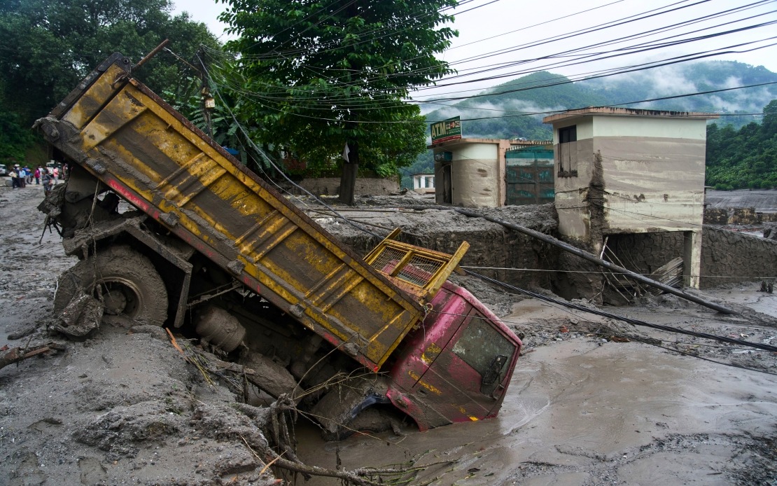
Nepal's National Disaster Risk Reduction and Management Authority has renewed warnings of imminent flooding along the Bhote Koshi River, where a catastrophic deluge struck the mountainous Rasuwa district on August 26. The alert came after water levels surged dramatically on Friday, carrying significant volumes of debris and mud through the same corridor that bore the brunt of the earlier disaster. The fresh warning underscores the precarious environmental conditions persisting in the region and the ongoing threat posed by Nepal's volatile monsoon season.
The Bhote Koshi River, which originates in the high Himalayan ranges and flows southward through steep terrain before merging with the Trishuli River, has become a focal point of concern for rescue operations and displacement management. The August 26 flash flood appears to have destabilised the riverbed and surrounding slopes, leaving accumulated debris that can be mobilised by subsequent water surges. This pattern of cascading hazards is common in Himalayan river systems during monsoon periods, particularly when heavy rainfall combines with unstable geology and glacial melt from higher elevations.
Authorities have instructed all personnel engaged in ongoing search and rescue operations, as well as relief distribution teams working along both the Bhote Koshi and Trishuli rivers, to maintain heightened vigilance. The instruction reflects the dangerous duality of the current situation: rescue workers and community members remain in vulnerable locations precisely where another inundation could strike with minimal warning. The NDRRMA's directive to move to higher ground immediately upon detecting any warning signs acknowledges the speed at which flash floods propagate through mountain valleys, often leaving only minutes for evacuation.
The death toll from the earlier flood has climbed to at least 475 people, with several hundred more persons unaccounted for as search operations continue downstream and in affected villages. The missing persons likely include individuals swept away by the initial surge or trapped beneath debris fields that rescue teams have not yet reached. The scale of casualties underscores both the intensity of the August 26 event and the challenge of locating bodies in remote, forested terrain where the river has deposited debris across wide areas.
For Southeast Asian countries sharing similar geography and climate patterns—particularly those along the Mekong River system and other major Himalayan-fed waterways—the Nepal situation offers cautionary lessons about disaster preparedness and early warning systems. Malaysia's experience with monsoon flooding, particularly in low-lying coastal and riverine areas, differs significantly from Nepal's mountain flood dynamics, yet both regions face challenges in balancing human settlement near productive river corridors with the inherent hazards of water systems in tropical and monsoon climates.
The Rasuwa district, located north of Kathmandu in the high Himalayas, sits in a region of considerable geotechnical sensitivity. The area experiences rapid snowmelt in spring months followed by intense monsoon precipitation from June through September. The combination of steep slopes, thin soil cover, and saturated conditions during monsoon season creates conditions where landslides and flash flooding become particularly hazardous. Infrastructure development in such regions—including roads, hydropower facilities, and settlements—can destabilise hillsides and increase water runoff velocity, potentially amplifying flood severity.
Nepal's disaster management framework has been strengthened considerably since major earthquakes in 2015, yet the challenge of protecting populations in mountainous terrain remains acute. The country's topography means that many communities remain geographically isolated for portions of the year, complicating both pre-disaster preparedness and post-disaster assistance delivery. The need for continuous monitoring of river conditions, particularly during monsoon months, has become increasingly apparent to regional governments across South Asia.
The alert issued on Friday demonstrates that Nepali authorities recognise the pattern of risk and are attempting to communicate warnings systematically to those still operating in affected areas. However, the practical challenge of ensuring that all exposed persons—including herders, labourers, and isolated villagers—receive and understand such warnings remains significant. Communication barriers, geographical isolation, and economic necessity that compels people to remain in or return to dangerous areas all complicate hazard mitigation.
Looking forward, the continued elevated water flow in the Bhote Koshi suggests that underlying conditions remain unstable. Saturated hillsides may continue to fail, sending additional debris into watercourses, while any renewed heavy rainfall could trigger further inundation. The period immediately following a major flood represents a window of heightened secondary risk, when the landscape has been destabilised but recovery processes have barely begun. Nepal's authorities face the demanding task of maintaining rescue operations and supporting displaced persons while simultaneously managing renewed hazard threats.
For regional observers, the Bhote Koshi situation illustrates the complex interplay between climate, geography, and human vulnerability that characterises much of South and Southeast Asia. As monsoon seasons grow more unpredictable and intense precipitation events occur with greater frequency, nations throughout the region must invest in early warning systems, community preparedness, and resilient infrastructure planning. Nepal's experience serves as a reminder that disaster management in mountainous regions demands sustained commitment, adequate funding, and cooperation across jurisdictional boundaries where major rivers cross international frontiers.

