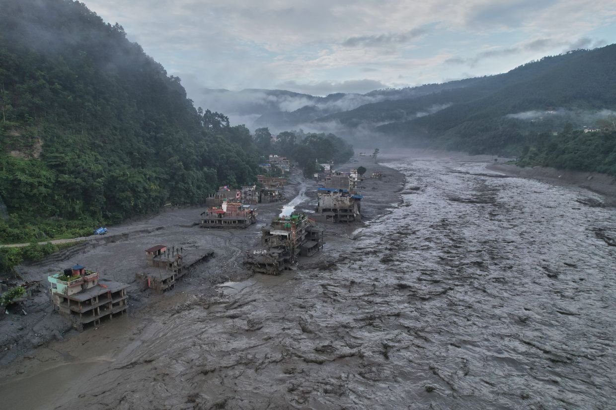
A catastrophic glacial collapse that triggered Nepal's worst flooding disaster in recent memory has laid bare a critical vulnerability in the region's disaster preparedness infrastructure: the absence of reliable early-warning systems in high-altitude zones and the limited cross-border sharing of crucial weather and climate information. The disaster, which unfolded on August 26 and claimed at least 800 lives whilst leaving more than 3,000 missing, occurred with communities receiving barely five minutes advance notice before torrents of ice, mud, rock and water surged through populated valleys. This stark reality has prompted urgent calls for strengthened monitoring mechanisms across the Tibetan Plateau and Himalayan region, areas where climatic instability is accelerating faster than institutional capacity can respond.
According to Dharam Raj Uprety, chief executive of Nepal's National Disaster Risk Reduction and Management Authority, the fundamental problem stems from the absence of weather stations in the highest mountain areas, a situation he directly attributes to inadequate trans-boundary data-sharing arrangements with neighbouring countries. Nepal lacks the technological infrastructure and financial resources to maintain comprehensive monitoring networks across remote terrain, whilst simultaneously missing real-time meteorological information that originates in upstream regions. This dual challenge means authorities operate with severe informational blindspots precisely where hazards are most likely to emerge. Uprety characterised the absence of effective data-sharing mechanisms as one of his agency's most pressing obstacles, one that demands urgent attention from both national and regional policymakers.
The August 26 event originated when bedrock beneath a glacier suddenly collapsed, unleashing a cascade of destruction that consumed entire settlements in its path. Dramatic footage captured residents attempting to flee as walls of water and debris engulfed homes, demolished bridges and power infrastructure, and swept away vegetation, massive boulders and vehicles. The scale of damage suggests reconstruction costs may reach at least US$5 billion, comparable to the extensive rebuilding effort that followed Nepal's devastating 2015 earthquake, according to assessments by Binod Chaudhary, Nepal's sole billionaire and head of the Chaudhary Group. The economic toll extends far beyond immediate infrastructure damage, with implications for tourism revenues and employment in a nation heavily dependent on Himalayan trekking and mountaineering as sources of foreign exchange.
The Chinese government has responded to the disaster by emphasising its commitment to enhanced glacier and glacial lake monitoring across the Tibetan Plateau. President Xi Jinping called for accelerated surveys of these high-altitude water bodies, while the Communist Party ordered strengthened early-warning systems to improve detection of interconnected disaster risks. In a statement posted on social media, the Chinese Embassy in Nepal asserted that China has consistently invested maximum effort within current technological capabilities to monitor, assess and analyse transboundary hazards, and that Beijing has shared relevant information with Kathmandu in a timely fashion. However, the embassy statement was notably non-specific regarding whether China had provided advance notice of the August 26 catastrophe, leaving unanswered questions about the quality and timeliness of existing data-sharing protocols.
The fundamental challenge confronting both nations involves the prohibitive expense and technical difficulty of establishing and maintaining observation infrastructure at extreme altitude. Weather stations capable of measuring rapidly fluctuating temperatures, permafrost stability and emerging glacial hazards require sophisticated equipment and consistent servicing in environments where access is severely constrained by geography and climate. Nepal's current monitoring capacity is concentrated in lower elevations and more accessible valleys, leaving vast stretches of high-altitude terrain with minimal observational coverage. This geographic distribution of monitoring infrastructure means that hazardous changes occurring in remote peaks reach authorities only through satellite analysis conducted after events have concluded, rather than through real-time data streams that might enable preventive action.
Scientific analysis of the glacier collapse indicates that bedrock failure triggered the cascading disaster, though researchers emphasise that direct attribution to climate change requires further investigation. Nevertheless, warming temperatures demonstrably weaken the permafrost that binds high-altitude slopes together, destabilising terrain that has remained stable for millennia. As greenhouse-gas concentrations continue rising, the pace of such destabilisation is accelerating, outstripping the speed at which monitoring systems and early-warning protocols can be deployed. The mismatch between the acceleration of environmental change and the lag in institutional response constitutes perhaps the most fundamental challenge facing disaster management authorities across the Himalayan region.
In response to the catastrophe, Nepal's disaster management authority has prioritised the development of improved early-warning systems and has drafted a comprehensive roadmap expected to receive official endorsement shortly. The initiative aims to provide mountain communities with substantially more advance notice before calamitous events, affording residents time to evacuate and move livestock and valuables to safety. However, the effectiveness of such systems depends critically on upstream information provision from China and other neighbouring countries, a requirement that current transboundary arrangements have manifestly failed to satisfy. Uprety stressed that unless nations abandon restrictive approaches to sharing climate and meteorological data across international borders, remote mountain communities will continue facing unacceptable hazard exposure.
The Nepal disaster carries implications extending well beyond the immediate humanitarian crisis. For Southeast Asian nations with mountainous terrain and significant populations in river valleys downstream of glaciers and high-altitude lakes, the lessons are sobering. Many countries across the region face comparable challenges in establishing adequate high-altitude monitoring and contend with transboundary water systems where upstream hazards can rapidly affect downstream populations. The absence of robust data-sharing mechanisms replicates Nepal's vulnerabilities across multiple borders and river basins. Regional cooperation frameworks remain underdeveloped relative to the scale of shared environmental hazards, suggesting that disaster preparedness in mountain Asia will remain compromised until governments prioritise cross-border information sharing alongside domestic infrastructure investment.
The economic and social dimensions of improved warning systems extend beyond saving lives during acute emergencies. Enhanced forecasting capabilities enable governments to implement longer-term protective measures for critical infrastructure, including hydroelectric dams, water supply systems and transportation networks that depend on understanding upstream hazards. Tourism industries operating in mountainous regions similarly benefit from more accurate assessment of hazard risks, allowing businesses to plan operations and schedule maintenance activities with greater confidence. For Nepal, a nation where mountain tourism generates substantial foreign exchange and employment, reducing uncertainty about glacial and weather-related hazards could provide a modest but genuine boost to economic stability and investor confidence.
The August 26 floods thus represent not merely a localised tragedy but a symptom of systemic institutional weakness in regional disaster governance. Addressing the underlying vulnerabilities will require investment in expensive high-altitude monitoring infrastructure, development of sophisticated data-processing and early-warning protocols, and—most challengingly—a transformation of national attitudes toward sharing climate and meteorological information across borders. The current arrangement, whereby countries restrict data sharing to maintain perceived advantages or protect sensitive information, manifestly fails to protect vulnerable populations in contested mountain zones. Without sustained political commitment to transboundary cooperation on environmental monitoring and disaster preparedness, similar catastrophes will recur with dismal regularity across the Himalayan region.

