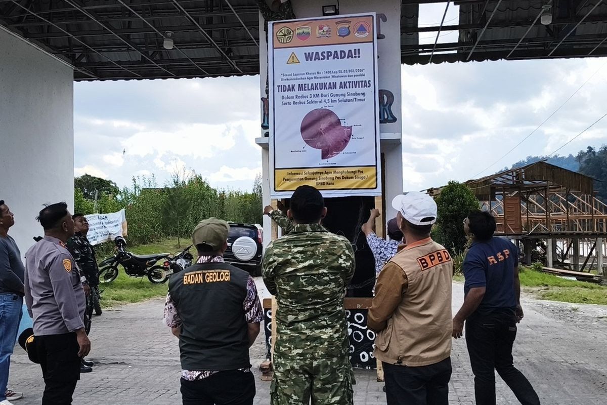
Indonesia's Karo regency has moved to restrict public access to key tourist attractions surrounding Mount Sinabung, one of the country's most unpredictable volcanoes, after geologists detected a significant uptick in volcanic tremors and elevated the hazard alert level. The administration implemented the closure from August 19, sealing off Lau Kawar Lake and an adjacent camping facility in Kuta Gugung village, Naman Teran district, for an indefinite period following guidance from the Vulcanology and Geological Disaster Mitigation Center's dedicated monitoring post at the volcano.
Juni Antomi Kemit, head of the Karo Youth Affairs, Sports and Tourism Agency, framed the measure as a precautionary step designed to safeguard both tourists and local communities as Mount Sinabung enters a period of heightened volatility. The decision was formalised through a directive issued by the Karo regent on August 14, which broadly discouraged all visitors, hikers and residents from venturing into areas surrounding the 2,460-metre peak. Officials have advised the public to maintain a minimum distance of three kilometres from the summit and to exercise heightened caution within a 4.5-kilometre radius of the southeastern sector, where pyroclastic flows pose the greatest danger.
The acceleration in volcanic indicators prompted authorities to upgrade the alert status from Level I Normal to Level II Waspada—the second tier in Indonesia's four-point early warning system. Armen Putra, the monitoring post commander, documented a notable increase in seismic frequency during the observation period. On Thursday, August 27, five volcanic earthquakes were recorded within a single morning, alongside multiple tectonic tremors. The previous day had registered only one volcanic quake and seven tectonic earthquakes, underscoring the rapid escalation in subterranean activity. Thick plumes of smoke have been observed rising between 100 and 800 metres above the crater, a visible indicator of magma movement within the volcanic system.
For communities dwelling along waterways fed by Mount Sinabung's streams, the advisory emphasises the heightened risk from lahars—catastrophic mudflows composed of volcanic debris and water that travel at speed down river valleys. These pyroclastic mixtures represent one of the volcano's most lethal hazard types and can cause destruction far beyond traditional evacuation zones. The regional government issued formal recommendations on August 13 instructing riverside populations to remain especially watchful, as such flows can occur with minimal warning during periods of elevated volcanic unrest.
Mount Sinabung's recent behaviour represents part of a long pattern of intermittent activity spanning more than a decade. The volcano had remained dormant for approximately four centuries before its initial recorded eruption on August 29, 2010, a relatively modest event that subsided within weeks. The situation changed dramatically with a second eruption beginning September 15, 2013, which escalated dramatically over the following weeks. By November 2013, Sinabung had entered Level IV Awas—the highest alert category—triggering a major crisis that claimed dozens of lives from superheated pyroclastic flows and forced the evacuation of populations from 21 villages and two hamlets across the surrounding region.
Following that catastrophic 2013 eruption, the volcano maintained a pattern of continuous activity throughout the subsequent six years, requiring sustained emergency management and periodic evacuations. Authorities gradually scaled back alert levels as instrumental readings improved, eventually downgrading the status to Level III Siaga in May 2019 after comprehensive analysis indicated the immediate threat had diminished. However, this apparent quiescence proved temporary. On July 28, 2021, Sinabung roared back to life with considerable force, hurling ash columns as high as 4,500 metres into the atmosphere while directing pyroclastic flows eastward across distances exceeding one kilometre. The 2021 eruption marked the volcano's most significant activity in a decade and affected no fewer than five districts, blanketing broad areas in thick volcanic dust that disrupted daily life across the region.
The current escalation carries particular significance for regional tourism and economic development, as the affected areas including Lau Kawar Lake have become increasingly popular with domestic and international visitors seeking trekking experiences and natural attractions in North Sumatra. The indefinite closure represents a substantial economic impact for local communities that depend on tourism revenue, yet such protective measures reflect hard-won lessons from prior eruptions. The 2013 crisis exposed the catastrophic consequences of inadequate evacuation and illustrated the necessity of rapid decision-making by authorities when volcanic indicators deteriorate.
Indonesia's volcanic monitoring infrastructure has improved considerably in recent years, allowing earlier detection of hazardous trends and faster implementation of preventive measures. The decision to close tourism facilities represents modern risk management informed by real-time seismic data and historical precedent. Geologists recognise that increased earthquake frequency typically correlates with magma ascending toward the surface, making the observed spike in tremor activity a legitimate cause for heightened vigilance. Each successive eruption cycle provides scientists with additional data about Sinabung's characteristic behaviour patterns, refining predictive models and response protocols.
The timing of this latest alert cycle underscores the persistent vulnerability that Indonesia faces as a nation situated along the Pacific Ring of Fire. With more active volcanoes than any other country globally, managing volcanic risk requires balancing public safety imperatives against economic considerations affecting millions of people in surrounding communities. The Karo regency's swift action demonstrates institutional capacity to prioritise safety when warning signs emerge, a capability that has strengthened markedly following the catastrophic events of 2013.
Tourists and climbers currently planning visits to North Sumatra should remain informed of the evolving situation, as alert levels may shift as monitoring data accumulates. The closure timeline remains uncertain; authorities will maintain restrictions until instrumental readings and visual observations confirm a sustained reduction in volcanic unrest. Indonesian disaster management officials have indicated they will communicate any status changes through official channels and local media outlets. For now, the restriction stands as both a precautionary boundary and a reminder of the powerful geological forces that shape life across Indonesia's volcanic landscape.

