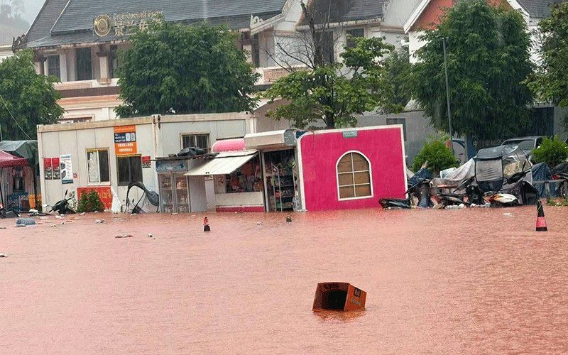
Luang Namtha province in northern Laos has been officially designated a disaster zone following catastrophic flash flooding that swept through the region over the weekend, with the Laos-China border crossing at Boten bearing the brunt of the deluge. The provincial administrative authorities made the declaration on Saturday after waters surged into the economically important Boten special economic zone and surrounding communities, leaving destruction across more than 30 villages and raising concerns about the stability of critical regional infrastructure.
The flooding event underscores the vulnerability of borderland communities to seasonal weather extremes, particularly in an era of intensifying monsoon patterns. The affected areas span Luang Namtha and Nalae districts, with damage extending across residential neighbourhoods, educational facilities and medical centres. Structures positioned near riverbanks and within low-lying zones experienced varying degrees of inundation, ranging from partial submersion to complete destruction. The airport serving the province sustained damage, whilst extensive tracts of farmland—critical for the region's agricultural economy—were submerged under water, threatening food security and rural livelihoods through the coming months.
The Boten border checkpoint, which serves as a major gateway for trade and travel between Laos and China's Yunnan province, remained operational despite the surrounding chaos. This preservation of the crossing is significant for both bilateral commerce and regional supply chains, though access routes to and from the checkpoint have been compromised. The Boten special economic zone, developed as part of broader China-Laos economic integration initiatives, represents a substantial investment and serves as an employment hub for thousands of workers across the border region.
Hydrometeorological data reveals the severity of the inundation. The Tha River, a critical waterway threading through the affected region, recorded water levels of 6.58 metres on the day of the declaration—substantially above the standard 6-metre flood warning threshold and dangerously approaching the 7-metre critical flood level where major overflow becomes inevitable. These measurements reflect the confluence of multiple upstream tributaries, all swollen from consecutive days of intense precipitation across the upper watershed. Authorities monitoring the hydrology station recognised the trajectory as exceptionally dangerous, prompting urgent warnings to downstream communities.
The meteorological conditions precipitating this disaster originated from a combination of atmospheric systems converging over northern Laos and adjacent southwestern China. A low-pressure system advancing southeastward from the Tibetan plateau merged with moisture-laden southwesterly monsoon flows, creating an ideal recipe for sustained heavy rainfall over the region's river basins. Weather forecasters issued flood alerts specifically for the Tha River through August 29-30, recognising that continued precipitation or upstream releases could exacerbate already dangerous conditions.
Provincial response mechanisms were activated rapidly following the declaration. District administrators across five divisions received instructions to mobilise warning systems targeting vulnerable populations clustered along riverbanks and in topographically depressed areas susceptible to flash accumulation. Contingency evacuation protocols were prepared, with officials instructed to remain vigilant and report developments to provincial command centres. The emphasis on coordinated early warning reflects lessons learned from previous disasters and the critical importance of timely communication in borderland areas where infrastructure and communication systems may be less robust than in urban centres.
The disaster extends well beyond Luang Namtha's immediate borders. A broader weather advisory encompassing fourteen provinces across northern and central Laos was issued for the weekend period, reflecting the scale of the atmospheric disturbance. The affected provinces form a geographical arc from Phongsaly in the extreme north through to Vientiane in the central lowlands, encompassing diverse terrain ranging from mountainous uplands to river valleys and plains. This geographic spread indicates a significant meteorological system rather than localised convective activity, with implications for water management across multiple river systems and administrative jurisdictions.
The weather system anticipated to persist through the weekend carried forecasts for scattered to intensive thunderstorms, moderate to heavy rainfall, and strong gusty winds. Such conditions historically increase the risk of secondary hazards including landslides on steep slopes, where saturated soil loses mechanical cohesion and slides downhill into valleys and agricultural areas. The combination of flash flooding and mass soil movement compounds rescue and recovery challenges, as access routes become severed and communities become isolated for extended periods.
Public health and safety directives urged residents throughout the warning zone to maintain close monitoring of weather developments and remain prepared for rapid evacuation if local conditions deteriorated. Particular emphasis was placed on communities inhabiting riparian zones and terrain depressions where water naturally congregates during extreme precipitation events. The message conveyed both the immediacy of the threat and the unpredictability inherent in flash flood situations, where water levels can rise within minutes once thresholds are breached.
The Luang Namtha disaster carries implications extending into regional economic corridors. The Laos-China border region has witnessed substantial infrastructure investment as part of the Belt and Road Initiative and broader economic cooperation frameworks, with Boten representing a flagship development site. Flooding of this magnitude threatens not only immediate recovery burdens on Laos but also complicates cross-border trade flows and may necessitate temporary diversions of commerce through alternative routes. For Malaysia and other Southeast Asian economies integrated into regional supply chains, disruptions along major border crossings can ripple through distribution networks and manufacturing timelines.
Climate analysts have noted that northern Laos sits at the intersection of multiple climate systems and topographic influences that can amplify precipitation intensity during monsoon seasons. The combination of high terrain channelling moisture-laden winds and rapidly rising river systems creates a particularly hazardous environment for communities dependent on riverine resources and agriculture. Future water resource management in the Mekong region will increasingly require sophisticated early warning systems and cross-border coordination to manage shared watershed risks effectively.

