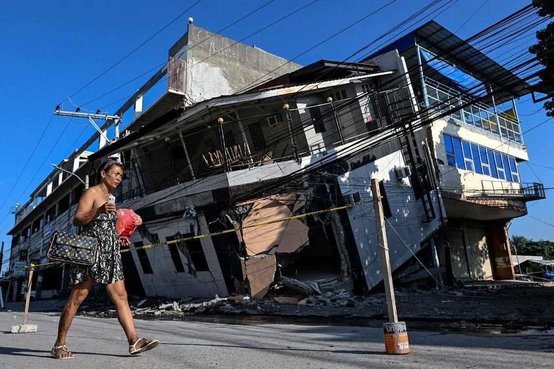
The June 8 earthquake that devastated Mindanao's southern coast did more than topple buildings and trigger landslides across the Philippines' second-largest island. The 7.8 magnitude tremor, originating from the nearby Cotabato Trench, triggered a geological phenomenon that has left residents grappling with an entirely transformed landscape—one that experts say will never return to its original state. Stretches of once-familiar shoreline have been thrust upward by metres, exposing vast expanses of previously submerged seabed and leaving at least 76 people dead across the region.
The catastrophic event has created an unprecedented humanitarian and psychological crisis. Fishing communities that have depended on specific coastal locations for generations now find themselves separated from the water by walls of jagged, bleached coral. Arsenio Butil Jr., a fisherman and pastor in Glan, Sarangani province, recounts experiencing the largest earthquake of his life and watching the shoreline transform before his eyes. He witnessed the water receding and returning repeatedly in what he describes as a terrifying display of nature's power, accompanied by dead fish floating in the churning waters. His testimony encapsulates the shock experienced by thousands of residents who lost both their homes and their bearings in a single violent event.
The geological mechanism behind this transformation involves what seismologists call coastal uplift, a process where tectonic forces thrust sections of the earth's crust upward. Nane Danlag, a researcher at the Philippines' seismology centre in General Santos City, confirmed that the seabed rose approximately two metres across the affected area, extending the shoreline by roughly 200 metres in some locations. The uplift stretched across a devastated zone spanning nearly 100 kilometres between two towns, fundamentally altering the geography that residents have known their entire lives. Danlag emphasised that this change is permanent, representing a new geological reality that communities must now accept and adapt to.
While the coastal transformation may seem catastrophic, Danlag places it within a longer geological timeline. The Cotabato Trench, positioned as close as 50 kilometres off Mindanao, sits at the junction of active tectonic plates where such upheavals have been occurring for thousands of years. The seismic activity that produced the June 8 earthquake was not anomalous but rather part of ongoing crustal movement that will continue reshaping the region's geography. In January, the area experienced a seismic swarm comprising thousands of smaller tremors, which a United Nations disaster risk reduction report issued in mid-May suggested could precede a larger seismic event—a warning that proved prescient.
The immediate aftermath has created a humanitarian crisis extending far beyond the visible physical destruction. In the hills above neighbouring villages, approximately 100 men, women, and children who fled to higher ground remain encamped, unable or unwilling to return to their destroyed homes. Datu Atom Malimpnig, a Maguindanaon chieftain representing the displaced group, explains that the newly formed coastline has shattered residents' confidence in their safety. The community fears that if the seabed can rise so dramatically, the sea itself could surge forward in a devastating tsunami. This anxiety, though scientifically distinct from the uplift phenomenon, reflects the profound psychological impact of witnessing fundamental environmental change. For these fishing families, the hilltop encampment, despite its hardship, feels significantly safer than their former coastal homes.
The economic implications of the coastal transformation extend beyond displaced families to the broader tourism sector. Edzel Baylon, a staff member at Isla Jardin del Mar resort, describes how the newly exposed coastline has devastated their business model. The resort's primary attraction—pristine white sand beaches suitable for swimming and water recreation—has been rendered unusable by the barrier of exposed coral and dramatically shallow waters. The transformation that took minutes has essentially erased the resort's competitive advantage and severely compromised its economic viability. This scenario represents just one example of how the earthquake's geological aftermath will reshape economic activities across the region for years to come.
The ongoing seismic activity has prevented any sense of normalcy or recovery in the affected areas. Since the June 8 earthquake, the region has experienced more than 8,500 aftershocks according to the Philippines' seismology agency, creating an environment of sustained anxiety and instability. Residents contemplating reconstruction efforts face a dangerous calculus: the ground beneath their former homes remains fractured with visible fissures, creating severe structural instability. Butil Jr., the pastor and fisherman, observes that another strong earthquake could cause further catastrophic damage to any structures built on such compromised earth. This assessment was immediately underscored when a 5.4 magnitude aftershock struck while he was speaking, a reminder that the region remains in active geological turmoil.
The disaster presents complex challenges for Philippine disaster management and urban planning authorities. Communities cannot simply rebuild in place on unstable ground while simultaneously grappling with the psychological trauma of witnessing their coastline disappear. The uplift phenomenon, while geologically routine, creates novel planning problems: former maritime routes are now impassable, fishing grounds have shifted, and traditional knowledge about local geography has become obsolete overnight. Authorities must develop comprehensive relocation and reconstruction strategies that account for both immediate safety concerns and long-term geological realities.
For Southeast Asia more broadly, the Mindanao earthquake and its coastal transformation serve as a stark reminder of the region's position along the Pacific Ring of Fire. The Philippines, Indonesia, and other neighbouring nations all sit atop volatile tectonic boundaries where large earthquakes and their secondary effects—tsunamis, landslides, and ground deformation—pose persistent hazards. The visible, permanent reshaping of Mindanao's coastline demonstrates that earthquakes create not merely temporary disruptions but enduring environmental changes that communities must learn to navigate. As climate change threatens coastal communities through rising seas and increased storm intensity, the additional stress of seismic ground deformation compounds the vulnerability of Southeast Asian populations living in tectonically active zones.