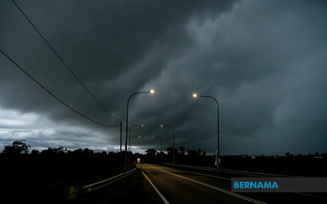
The Malaysian Meteorological Department has activated a comprehensive weather alert covering nine states and the federal territory of Labuan, warning residents and travellers to prepare for potentially hazardous conditions including thunderstorms, heavy downpours and strong winds throughout the afternoon and early evening. The alert, which remains in effect until 9 pm today, represents a significant weather system affecting multiple regions across Peninsular Malaysia, Sarawak and Sabah simultaneously.
In northern Peninsular Malaysia, the entire state of Perlis falls under the warning zone, making it particularly vulnerable to the approaching weather system. Neighbouring Kedah also faces considerable risk, with the alert specifically targeting the districts of Langkawi, Kubang Pasu, Kota Setar, Pokok Sena, Padang Terap, Sik and Baling. These areas, which include popular tourist destinations and densely populated urban centres, should see intensified weather activity as the system moves through the region. Perak likewise experiences coverage across multiple districts, including Kerian, Larut, Matang and Selama, Kuala Kangsar, Kinta and Kampar, indicating the system's broad geographical reach.
Central Malaysian states are also in the warning's purview. In Pahang, the alert encompasses the highland regions of Cameron Highlands as well as the eastern districts of Bentong, Bera and Rompin. These varied terrain zones—from mountainous areas to lowland plains—may experience different intensities of the weather phenomenon. Selangor, Malaysia's most densely populated state, faces potential impacts in the Hulu Langat district, which encompasses both the capital's water catchment areas and suburban communities. Negeri Sembilan's Jelebu and Jempol districts complete the Peninsula's warning coverage. In the southern region, Johor's Segamat, Kluang and Mersing areas have been flagged for attention, covering both inland and east coast zones that may experience significant disruption.
The weather alert extends substantially into East Malaysia, demonstrating the scale and severity of the meteorological system. In Sarawak, coverage is exceptionally broad, affecting Kuching's divisions of Bau and central Kuching, the Serian division, Samarahan (encompassing both Samarahan and Asajaya), Sarikei's Meradong area, the Sibu division, Mukah's Tanjung Manis district, Kapit's Song and Kapit divisions, and the Bintulu regions of Tatau and Sebauh. The northern divisions also face warnings, with Miri's Marudi district and the entire Limbang division under alert. This comprehensive coverage suggests Sarawak's western and central regions will experience the most significant weather activity.
Sabah's warning similarly encompasses multiple geographic zones across the state. The interior districts of Sipitang, Kuala Penyu, Beaufort and Tambunan face the alert, along with the entire west coast region. In the east, Sandakan's districts of Tongod and Kinabatangan are also included. The federal territory of Labuan, positioned in the north, rounds out the affected areas. This distribution pattern indicates the weather system is affecting both coastal and inland regions with potentially comparable intensity.
Thunderstorm warnings of this scale and geographic breadth carry significant implications for public safety and economic activity. Residents in affected areas should prepare for sudden onset of heavy rainfall that could lead to flash flooding, particularly in low-lying areas and river valleys. The strong winds accompanying the system pose risks to outdoor installations, vehicles and pedestrians. Those planning travel during this period—whether by road, air or sea—should anticipate potential disruptions and delays. Commercial activities, including construction sites, outdoor events and agricultural operations, may face temporary interruptions. Schools and public institutions in these zones should assess whether outdoor activities require adjustment or postponement.
The timing of the alert until 9 pm suggests the most severe conditions are expected during late afternoon and early evening hours, when electrical activity from thunderstorms typically peaks. Residents should monitor local weather updates closely and follow guidance from emergency services. Those living in flood-prone areas or areas with poor drainage should take preventive measures. Motorists should exercise extra caution, particularly on highways, where reduced visibility and wet road conditions create hazardous driving situations. Individuals working outdoors should seek shelter immediately when conditions deteriorate.
For businesses and infrastructure operators, such comprehensive weather alerts necessitate contingency planning. Public transport operators may need to adjust schedules or routes to avoid flood-affected areas. Utility companies should prepare for potential outages from lightning strikes or wind damage. Agricultural producers in affected regions might consider protective measures for vulnerable crops. The energy sector, already managing regional demand, may see fluctuations in renewable energy generation from solar installations during the storm period.
The scope of MetMalaysia's warning reflects modern meteorological monitoring capabilities and the importance of early public notification. By providing specific district-level detail and a clear time window, the department enables targeted responses from various authorities and individuals. This precision helps distinguish between areas requiring maximum alertness and those experiencing marginal risk. The inclusion of both Peninsular Malaysia and East Malaysia indicates a significant weather system with substantial geographical influence, possibly connected to broader monsoon patterns or tropical disturbances affecting the entire region.